1. INTRODUCTION
It is known that Nikola Tesla said in the thirties of the last century that he had progressed so far in the study of vibrations that he could create a new science “TELEGEODYNAMICS”, which would determine not only the problems of transmitting powerful impulses through the earth to distant places, but in addition, by applying the same principle, could discover mineral wealth deep below the earth’s surface.
Tesla stated that he could apply these same principles to the detection of distant submarines and ships, even when they were anchored and the ship’s engines were not working. The TELEGEODYNAMICS system, which uses mechanical vibrations, Tesla said, would be able to determine the earth’s constant and discover the mineral treasure hidden deep below the surface. Tesla expected important results from “TELEGEODYNAMICS”, but he was unable to do so until his death
realizes – verifies those ideas in the field of remote detection of objects and discovery of mineral treasures hidden deep under the earth’s surface. Guided by Tesla’s ideas, we managed to discover resonant frequencies of oscillation
elements of the periodic system, to construct the device “DEPS-2017” and develop original methods for horizontal and vertical electromagnetic prospecting for finding oil, gas, ores, minerals, water and various other compounds, as well as an interference method for determining their chemical composition, which is based on the aforementioned discovery.
The conducted research served us to confirm the accuracy of the detected oscillation frequencies, and then as a basis for the construction of the “DEPS – 2017” detection device.
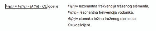
We found that all the elements of Mendeleev’s periodic system have different resonance frequencies, from the lightest by atomic weight – hydrogen, with the highest frequency, to the heaviest – nobelium, that is, the element with the lowest frequency.
If Mendeleev arranged the elements in the periodic table according to atomic weight, with the discovery of the oscillation frequencies of the elements, their arrangement was arranged according to the numerical value of the oscillation frequencies, which is identical to the arrangement according to Mendeleev.
Oscillation frequencies of elements of the periodic system are determined by the formula:
The discovery of the formula for calculating the oscillation frequencies of the elements of the periodic system, the construction of the new invention “DEPS – 2017” and the verification of new methods for electromagnetic prospecting, as well as the interference method for determining the chemical composition, provided the basis for a new science called “GEOVIBROLOGY”. GEOVIBROLOGY (from, GEA – earth, VIBRO – oscillations and LOGOS – science), broadly speaking, the science of vibrations (oscillations) of elements of the periodic table originating from the earth. The new invention “DEPS – 2017” and verified methods have proven to be effective in detecting oil, gas, ores, minerals, water and various other compounds, as well as determining their chemical composition.
NON-INVASIVE METHOD FOR PROSPECTING WATER, OIL, ORE, AND MINERALS
The discovery of the formula for calculating the oscillation frequencies of the elements of the periodic system, the construction of the new invention “DEPS – 2017” and the verification of new methods for electromagnetic prospecting, as well as the interference method for determining the chemical composition, provided the basis for a new science called “GEOVIBROLOGY”. GEOVIBROLOGY (from, GEA – earth, VIBRO – oscillations and LOGOS – science), broadly speaking, the science of vibrations (oscillations) of elements of the periodic table originating from the earth. The new invention “DEPS – 2017” and verified methods have proven to be effective in detecting oil, gas, ores, minerals, water and various other compounds, as well as determining their chemical composition.

2. TECHNICAL SPECIFICATIONS OF “DEPS – 2017”
“DEPS – 2017” is a device for detection, precise location and depth determination of various materials in the ground. According to the method of detection, it belongs to a group of devices from the field of electromagnetic prospecting whose work is based on the resonant method of detection.
The device set “DEPS – 2017” is shown on the front page. In its set, the device contains:
> special transmitting antenna (NF emitter),
> base unit electronics with signal generator,
> sensor arrow,
> accumulator battery,
> connecting cable with “cigarette” connector for powering the base unit and controlling the state of the accumulator battery,
> battery charger AC 220/DC 12 V,
> three-legged stand with rotating platform for transmitting antenna,
> digital multimeter
> other auxiliary equipment (transformer voltage DC 12 V – AC 220 V,. aggregate 220 V, 600 W,
GPS receiver, radio stations) which is shown in Figure 1.
> device mass ………………………………………… …………………………………………… …..1.1 kg,
> mass of kit…………………………………………… …………………………………………… ……7 kg.

Figure 1 – Mobile prospecting kit with signal generator
3. ELECTROMAGNETIC PROSPECTING
The term prospecting refers to the examination of soil in order to search for oil, gas, ores, minerals, water and various other compounds and materials in the ground.
The earth’s crust has a very complex composition and it should be borne in mind that false results (false reflections) can be obtained during prospecting. Since the periodic table has 118 elements, this means that the earth is theoretically composed of 118 factorials of different compounds, which is impossible to detect in practice. By precisely and accurately calibrating the resonant frequencies of the desired compounds, with strictly discriminated values, false reflections can be reduced and the probability of detection can be increased, but current research shows that the probability of detection is around 90%. With water, oil, gas, gold, platinum, tungsten, uranium and lead, about 98% and other non-ferrous metals about 85%
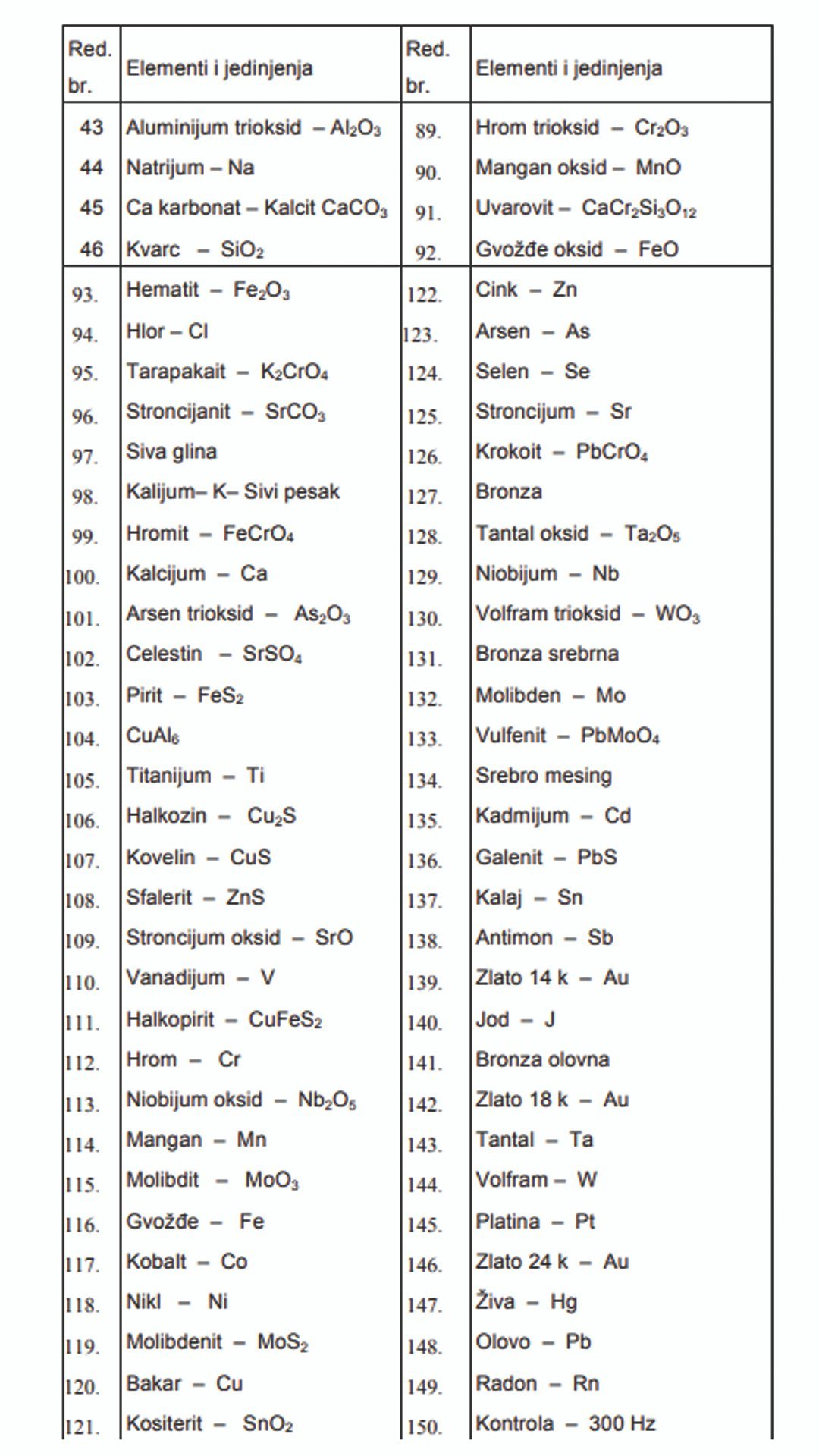
Table 1 shows an overview of some of the elements and compounds whose frequencies have been implemented in “DEPS – 2017” so far.
3.1. HORIZONTAL PROSPECTING
The desired frequency is set using the buttons on the control panel. By turning on the device, the transmitting antenna radiates a beam in the desired direction with a width of 20 cm, a range of over 8000 meters. The transmitted beam from the transmitting antenna interferes with the searched water, oil, ore or minerals located on or in the ground to create a search beam. The request stream is registered – detects with a sensor arrow. When the operator enters the interference field of the desired element, the sensor arrow moves in the direction of flow, and the intensity of the field is read on the scale of the sensor arrow disc. The coordinates of the edges of the flow and the ore body are registered using a GPS receiver. The detection procedure is repeated for several points and thus defines the edge of the flow or the boundary of the ore body.
Table 1 – Overview of Elements and Compounds for “DEPS – 2017”
| A row. no. | Elements and compounds | A row. no. | Elements and compounds |
| 1 | Hydrogen – H | 47. | Malachite |
| 2 | Lithium – Li | 48. | Phosphate – PO 4 |
| 3 | Ammonia – NH 3 | 49. | Hydrated hematite – Fe 2 O 3 ‘ nH 2 O |
| 4 | Hydrocarbons – C n H m | 50. | Andesine – NaAlSiO |
| 5 | Hydrazine – N 2 H 4 ‘ – NH 4 | 51. | Kaolin |
| 6 | Water Zlatibor | 52. | MnSO 4 – 4H 2 O |
| 7 | Voda Jana | 53. | SO 4 – SO 3 |
| 8 | Water Vuji% | 54. | Rose quartz |
| 9 | Voda Vrnjci | 55. | Dolomite – CaCO 3 ‘ MgCO 3 |
| 10 | Minakva water | 56. | Al 2 O 3 +SiO 2 – AlSiO 4 |
| 11 | Water Demi | 57. | Magnesium – Mg |
| 12 | Spring water – H 2 O | 58. | Vranjska water |
| A row. no. | Elements and compounds | A row. no. | Elements and compounds |
| 13 | Bor – B | 59. | Breakdown of water NaClMgSCCaKPFHO |
| 14 | Hydrocarbonate – HCO 3 | 60. | Carnelian |
| 15 | TNT – Serbia | 61. | Hydrated bauxite Al 2 O 3 +Fe 2 O 3 +SiO 2 +H 2 O |
| 16 | Oil | 62. | Water Prince Milo! |
| 17 | Phenol – C 6 H 5 OH | 63. | Biotite – KMgFeAlSiFOH |
| 18 | TNT – Europe | 64. | Clay |
| 19 | Boron trioxide – B 2 O 3 | 65. | Naphtha – CHNOSSiCaKFeAlMg |
| 20 | Opal – Carbon | 66. | Aluminum – Al |
| 21 | Carbon – C | 67. | Horblende CaNaMgFeAlSiOH |
| 22 | Hydrated aluminum trioxide Al 2 O 3 ‘ H 2 O | 68. | Andesite NaAlSiCaMgFeKFHO |
| 23 | Oil | 69. | Potassium oxide – K 2 O |
| 24 | Nitrogen – N | 70. | Fine sand |
| 25 | Carbon dioxide – CO 2 | 71. | Amethyst shines |
| 26 | Nitrates – NO 3 – Nitrites NO 2 | 72. | MnSO 4 |
| 27 | Organic part of oil – CHNOS | 73. | Dark amethyst |
| 28 | Oxygen – O | 74. | Calcium oxide – CaO |
| 29 | Opal – ore | 75. | Lapis lazuli |
| 30 | Hydrogen sulphide – H 2 S | 76. | Sea salt – NaCl |
| 31 | Sodium nitrate – NaNO 3 | 77. | Rock salt – NaCl |
| 32 | Pyralene – C 12 H 2 Cl 8 | 78. | Calcium phosphate |
| 33 | Phenol – C 6 H 5 -Cl-NaOH | 79. | Silicon – Si |
| 34 | Magnesite – MgCO 3 | 80. | Augite – CaNaMgFeAlSiO |
| 35 | Kaolinite – SiO 2 ‘Al 2 O 3 ‘ H 2 O | 81. | Titanium dioxide – TiO 2 |
| 36 | Fluorine – F | 82. | Phosphorus – P |
| 37 38 39 40 41 42 | Black powder Colemanite – Ca2B6ABOUT11‘5H2O Sodium oxide – Na2O Citrine Magnesium oxide – MgO Howlite – Ca2B5SiO9(OH)5 | 83. 84. 85. 86. 87. 88. | Hyperthene – MgFeSiOBauxite – Al 2 O 3 +Fe 2 O 3 +SiO 2 Sulfur – SVanadium oxide – V 2 O 5 Turquoise Opal – Fe, Al |
3.1. VERTICAL PROSPECTING
In order to determine the depth of oil, water, ore and minerals, after leveling on a horizontal stand, the transmitting antenna is directed into the ground using a laser spirit level, and after that, a sensor arrow is used to search for the reflected beam resulting from the interference of the emission beam from the required material at an angle of 45 °. The distance from the device to the reflected beam corresponds to the depth at which the object is located (l = h). A graphic representation of the depth measurement is given in Figure 3.

In vertical prospecting, it is possible to record the geological composition of the soil up to a depth of 8000 meters with minor deviations. Also, in vertical prospecting, the thickness, that is, the section of the ore body or the size of the object can be determined.
4. RESEARCH AND VERIFICATION OF DEPS – 2017 IN THE FIELD
– In the last seven years, intensive work has been done on improving the equipment and checking its efficiency when working on concession fields in various countries, and at the same time research and knowledge of the state of the ore body outside the concession fields. Research on in the concession field is research on partially known terrain, and research outside the concession field is research on unknown terrain, where the results are obtained later proves. During these seven years, the research was carried out in Russia, Kazakhstan, Kyrgyzstan, Iran, (Pania, Pakistan, Montenegro, Croatia, Bosnia and Herzegovina, Serbia and Cameroon, etc.
5 . RESEARCH RESULTS
a) Russia
– In the copper mine, Republic of Bashkiria, deposits of chalcopyrite ore body were determined. The mine exhausted the ore body of surface exploitation, so it was switched to pit mining exploitation. The exact positions of the ore body deposits in the north-east are defined part of the mine. Next to the chalcopyrite ore deposit in one pit, the position of the gold deposit was defined.
– On the oil field in North Ossetia, an analysis of the situation in the region of five wells was carried out. Two wells are completely dry because they missed the oil ore body, and the other three are on edge of the ore body, so the productivity of those wells is small. It is interesting that the wells are up to 4000 meters deep missed the ore body and the other three that are on the edge of the ore body drilled to a depth of up to 2500 m. What is characteristic of this oil field is that in in the region at a depth of 3500 m and up to 5000 m there are still three very rich layers of oil.
– In the area of Sub-Moscow – the southern part of Moscow, oil and gas prospecting was carried out, but the existence of any hydrocarbons was not detected up to a depth of 8000 m.
– In the Republic of Bashkiria, soil contamination with oil products leaking from old reservoirs and contaminating underground watercourses was detected.
b) Kazakhstan
– The area of the city of Karaganda is very rich in coal of the brand – Anthracite. On one of The concession is defined by three layers of ore bodies at a depth of up to 180 m. In addition to defining the position of the ore bodies and the detection of the presence of Methane pockets was made. Methane is not detected. In addition to coal, underground water positions were detected in an area of 100 km north – east of the city of Karaganda.
– The region of Ust Kamenogorsk is rich in polymetallic ores of copper, zinc, lead, silver and gold. On one of the concession fields, we defined the positions of ore deposit of gold. It is very interesting here that the depth of the ore body is from 15 to 25 ma layout of the ore body on the concession in the shape of a tiger skin.
– The coast of the Caspian Sea is too rich in natural gas and oil. North of the city of Aktau on the concession field of 36 km 2 over 100 boreholes were drilled. Here is the spawn oil in the first layer at 440 m and the second layer at 550 m. There are a lot of wells that are dry and also those that are on the edge of the ore body. Yield of the concession according to the investment in the concession itself is unfavorable.
c) Kyrgyzstan
– In Kyrgyzstan, we detected gold at a gold mine concession 150 km east of of the city of Bishkek. The altitude of the mine is 2200 m. The thickness of the ore body is about 90 m with an exceptional proportion of gold ranging from 5 to 30 g/t in some places and up to 90 g/t of ore.
– Kyrgyzstan is interesting in that we detected a very rich deposit of both gold and oil in a free area at a distance of about 120 km east of the capital .
d) Iran
– In the areas of the cities of Gilan Harb and Khoramoabad on nine concession fields deposits of rock asphalt were detected. Asphalt is practically found on the surface and it moves to a depth of 70 m on average. The two concession fields are very rich, one se is located near the town of Mamulon and the other is in the Wadud region.
– Two copper mines were detected in the area of the town of Aligudarci. One is ore Kovelina on an area of 3 km 2 and the other is Halkozina with an area of about 2 km 2. In addition to these two copper mines, two more mines were detected, one of Chromite with an area of about 4 km 2 and the other of Molybdenum and Tungsten with an area of 2 km 2 . This space is extremely rich polymetallic ores.
– The region of the city of Yazd is a pearl among pearls. It is located 130 km north-east of the city is a region rich in polymetallic ores. On an area of 150 km2 there is a mine copper where about 15 different ores were detected. Copper ores: Azurite, Malachite and Chalcozine in one place are a real rarity where ore concentrations range from 5 – 15% and in some parts they go up to 40%. Besides copper there are Zinc, Lead, Silver, Gold, Platinum, Molybdenum, Cobalt, Tungsten, Iron and in some parts Barium, Vanadium, Phosphorus, Titanium etc. were also detected. One small part of the ore body is in the mountains, and the rest is on the gentle slope of the rocky desert. At the beginning of the ore body, the thickness of the ore body ranges from 560 m to about 800 m in the mountainous part. Azurite and Malachite are found in the first half of the thickness. (that is still interesting for this area. To the northeast of this ore body, the Manganese ore body continues.
– In Iran, we had planned to examine several more areas of the cities: Paul Daktar, Tabriz, Kerman, (Iraz and coast of all seas. In Tehran, we had a meeting with Director of the Iranian Oil Company for Oil and Gas Exploitation.
e) Montenegro
– On the territory of the state of Montenegro, detections were carried out in the area of underground water, bauxite, coal and oil. Water, bauxite and coal are already in exploitation, and oil was detected outside the official system, that is, by the research of the inventors themselves.
f) Croatia
– Oil fields have been detected in the area called Slavonia and they are being exploited.
d) Bosnia and Herzegovina
– In addition to detecting the elements of coal, bauxite and iron in the concession fields approx the towns of Zvornik and Prijedor. Prospecting of the terrain in western Bosnia has shown that an area rich in ores, especially the deposit of Salt (NaCl) and oil, very rich layers.
h) Pakistan
– Pakistan, a high-risk country for foreigners to work in the field, oil was detected at a depth of 5000 m.
i) Spain
– In Spain, a demonstration of the operation of the equipment was carried out at the training ground of the future mine of polymetallic ores.
j) Serbia
– The authors of the invention detected Copper, Zinc, Boron, Lithium ores in the territory of Serbia, Beryllium, Gold, Water, Gas and Oil. In addition to ores, they also worked on defining archaeological ones excavation.
k) Cameroon
– In Cameroon, research was carried out in the jungle and six mines of gold, platinum, palladium, silver, copper, titanium, iron, tungsten, lead, oil and three more were detected. rare metal. Gold was also detected in river sediments in the basin of the Sange and Ngoko rivers.!!